


PARRC's Unveils New Recreation Guide StoryMap
- parrcoordinator
- Jul 7, 2025
- 3 min read
The Pottstown Area Regional Recreation Committee (PARRC) StoryMap is now available to view. It is an interactive and user-friendly digital experience. The StoryMap is a Parks and Trail Guide that highlights the major parks of the eight municipalities of the PARRC region, showcasing each community through engaging stories, photos, and videos. It provides useful information about the region's parks, trails and recreation areas, including location, size, facilities, parking and more, from serene nature trails to large community parks, as well as a comprehensive list of the smaller neighborhood parks that contribute to the region.
The StoryMap was developed in partnership with the Appalachian Mountain Club as an outreach, education, and marketing tool to promote the region's parks and trails to the public, partner organizations, and stakeholders. Project funding was provided from the Pottstown Area Health & Wellness Foundation and a private donor. Continue reading below for a detailed description of how to use and navigate the PARRC StoryMap.
Using the Recreation Guide StoryMap
Navigation
Just below the title slide is the navigation bar, which allows you to easily move between the
eleven sections of the StoryMap. The PARRC Region section provides background information on PARRC and highlights the economic value of outdoor recreation in Pennsylvania. The Discover PARRC Parks & Trails section contains an interactive map of the major park and recreation resources of the eight communities. Next on the navigation bar are the eight municipalities of PARRC, and each section contains information about that community and highlights its major parks. Last, an Acknowledgement section thanks the funders for this project.

To view the StoryMap, you can either scroll through it or click on a section title to go directly to that section. To return to the title slide or the beginning of the StoryMap, simply click on the title at the top.
The PARRC Region
The PARRC Region section provides information on PARRC’s background and region. This region covers 75 square miles and contains over 2,600 acres of state, county, and local park, recreation, and open space land. Also included is information on the economic value of its parks, trails, and open spaces, including videos and graphics.
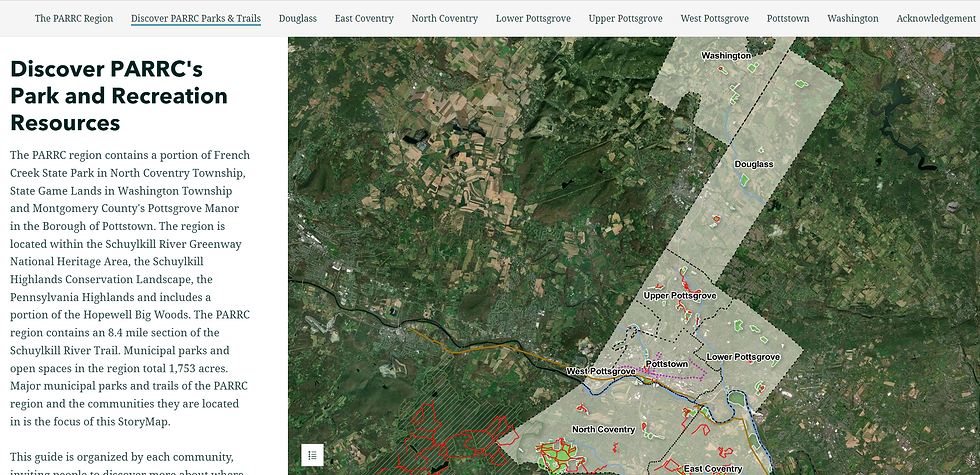
Discover PARRC's Park and Recreation Resources
In this section, the interactive map provides context and location for each of the eight municipalities. The map displays the PARRC region along with parks and open spaces, and a legend is available by clicking on the button in the lower left-hand corner of the map. Clicking on a park will display information, including the address, a photo, available activities, pedestrian and ADA access, park amenities, trail surface (if applicable), public transportation details, and a link for additional information.
Municipalities
Each municipal section includes an introductory slide with details about the area such as population, retail areas, and major roads. As you scroll through the section, the major parks of the community are highlighted. Each featured park includes information such as its address and size, with a map showing its location. Users can zoom in/out, view photos, watch videos, and access park maps where available. The photos and videos were chosen to convey a sense of place and community. At the end of each section, a list of smaller municipal parks and open spaces is provided.

Designed with ease of use in mind, the Parks and Trails StoryMap ensures a seamless experience for Pottstown area residents and visitors alike. Whether you're looking to learn more about the past, plan your next outdoor adventure, or discover hidden gems within the community, this tool is the perfect guide to exploring everything the Pottstown area has to offer.
Stay tuned for the official launch and get ready to experience the PARRC region like never before!


Comments